

Ge-Path
freeware
[Home] [Ge-Graph] [KML Color converter] [Scale 2.0] [Climogram]
|
[Browse questions &
answers/comments/suggestions/bug reports] [GE-Path/Graph in the
Web]
|
|
GE-Path: Make
Path for GoogleEarth Free Freeware v 1.4.6 19-January-2012 Compatible with Google Earth version 6.1 Features
total path distance from saved Path files (kml) |
AREA FIX
The previous versions of GE-Path have a bug in the calculation of the surface's area, for small areas. This bug came from the use of a single algorithm (spherical polygons) to calculate areas of any size. The present version continue to use this algorithm for large areas calculation and made available also another algorithm for small area calculations, based on the conversion of the coordinates to UTM system . Now you choose the method: Small for areas smaller then 1000 ha (2500 acres) and Large for larger areas.
(unzip the file in a temporary folder and run setup.exe)
If you have already installed
the previous version you can download only the updated executable and the help
file. Unpack in the application directory and update your shortcuts.
Download updated
executable 1.4.6 (85 k)
Requires vb6 runtimes and ![]()
Download previous version (GE-Path 1.4.4a)
| Use it just for fun. Take a look in the Help File (gepath1_4_3.chm) (408k)
Version historyVersion 1.4.6 19/02/2012
Version 1.4.5 20/11/2011
Version 1.4.4a 01/08/2009
Version 1.4.4 15/02/2009
Version 1.4.3 15/08/2008
Version 1.4.2 25/08/2007
Version 1.4.1 14/06/2006
Version 1.4.0 24/05/2006
Version 1.3.0 19/04/2006
Version 1.2.03 02/03/2006
Version 1.2.02 05/02/2006
|
Quick start
1. Create a folder in GE and create, move or copy your place marks there, or create a Path file (GE-Plus and Pro). 2. Save it as KML file; 3. Open the file with GE-Path; 4. Choose your options and click in 'Run'; 5. Choose a file name when prompted and save it.
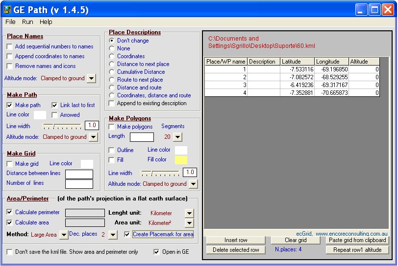
Screenshot
Download this sample (.kmz) |
 |
 |
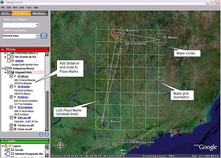
Thanks to Terry Pinnell for the input Path file
Please report bugs / comment / suggest
Technical Specification
Distance
We created, in Google Earth, 22 placemarks with distances from each other ranging from 3.500 km to 6 meters. With the ruler tool, in GE, we made careful measurements. Then we have compared these measurements with the ones made with GE-Path, as presented in the figure below. You can download the Excel file with the data (coordinates and distances) presented here (The area data is also included) . You can download also the kml file with the placemarks used.
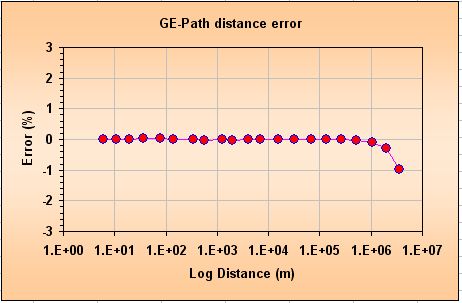
Up to 1,000 km the distance error in GE-Path is almost zero. In 3,500 km the error increases to -1% which corresponds to 35 km.
Área
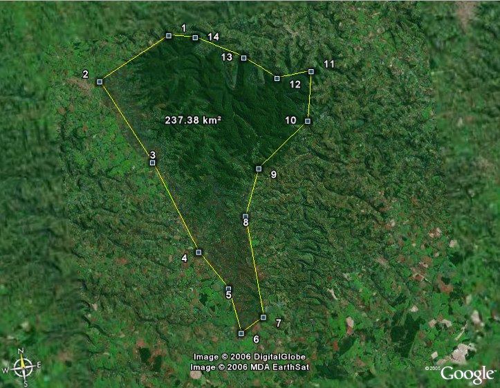
We have choosen, around the world, six areas with size ranging from 200 square meters to more than 1 million square kilometers. We got the actual size of each area from information available in the internet. Each area was then measured with GE-Path. The error (%) is the difference between the actual area and the measured area divided by the actual area and multiplied by 100. You can download the Excel file with the data presented here (the distance data is also included) and the kml file with the areas coordinates.
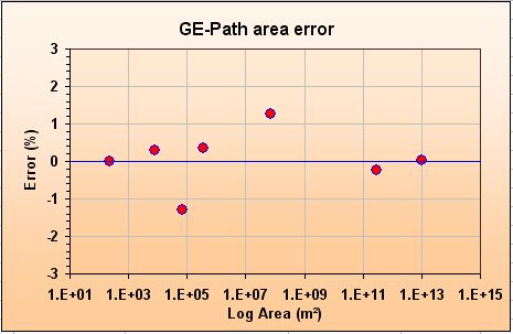
The error ranges from -1% to 1% well distributed around the zero error line and seems to be due to the localization of the polygons (placemarks) in Google Earth.
The bug in the installer of the application is fixed in this version (2.2.2a) thanks to the contribution of John Davies
R.Sgrillo
Cocoa Research Center (CEPLAC/CEPEC)
Ilheus, Bahia
Brasil